Documents
Altimetry Data Assimilation Chain for Multi-resolution River Flow Models
J. Monnier (IMT-INSA Toulouse), P.-A. Garambois (ICUBE-INSA Strasbourg), K. Larnier (CS corp.-IMT-ICUBE, CNES), A. Montazem (LEGOS-ICUBE), S. Calmant (LEGOS-IRD), and S. Biancamaria (LEGOS-CNRS), France
Objectives & the HiVDI Algorithm
This research project aims at elaborating numerical flows models and inference algorithms for rivers which will be observed by the forthcoming SWOT mission. The inference algorithms aim at estimating from altimetry data: the river discharge Q(x,t) plus an effective bathymetry b(x) with corresponding roughness coefficients K(.).
To solve this challenging inverse problem, a complete hydraulic chain (0.5D - 1D - 2D) has been developed. It includes dedicated original systems and state-of-the-art know-hows in Variational Data Assimilation (VDA). The resulting direct-inverse computations led to the so-called Hierarchical Variational Discharge Estimation (HiVDI) algorithm [1][3].
In this note some capabilities of the HiVDI algorithm are illustrated on a few examples. The computational codes (including interfacing tools with SWOT HR simulator, QGis pluggings) are open-source; they are available upon simple request on DassFlow webpage [Dass].
Method
The key ingredients and know-hows in HiVDI algorithm to infer the unknown river properties (discharge, bathymetry and roughness) are the following:
- Multi-dimensional/scale flows models: original low-complexity 0.5D system (see [1]) plus the classical 1D and 2D shallow flow models, see [3][5];
- Advanced formulations of Variational Data Assimilation (VDA) (including potential prior information, and with adequate covariance operators) [1][3][5][7-8];
- Fine analyses of the inverse problem through “Identifiability Maps” (see [3] and e.g. Fig. 3) and of the flow lines signal (see [2] and e.g. Fig. 5);
- Assimilation of potentially available databases (e.g. SWOT river database).
The dedicated low-complexity 0.5D model [1] (Low Froude steady-state flow assumption, Manning-Strickler's law is part of it) enables to:
- estimate consistent first guess values of (Q,A0 (x),K(.)) for the iterative VDA (optimization) process;
- estimate accurate effective bathymetries b(x) (equivalently unobserved wetted cross-section A0 (x) if one (1 only) in-situ measurement is available;
- perform in real-time discharge estimations, past one year "learning period".
Finally, the HiVDI algorithm (the advanced VDA processes combined with the hierarchical models chain) enables to (see [1]):
- infer space-time discharge Q(x,t) values plus an effective bathymetry b(x) (at nodes scales, ~200m) with corresponding roughness coefficients K(x) during the one year learning period (K may potentially be defined as a power-law). Passed the learning period, the low-complexity model can be re-calibrated. Then given newly acquired SWOT measurements,
- estimate the discharge at "reach" scale (~1km length scale) in real-time (see e.g. Fig. 4.)
The VDA processes have been developed both for 1D river branches [1][3] and for 2D flows (braided rivers, flood plains) [5]. Moreover a two-ways coupling 1D-2D, by superposing local 2D models over a global 1D, has been established, but up to now in academic contexts only [7-8].
Results
The inference capabilities have been investigated in detail for more than a dozen of worldwide rivers. The numerical experiments are based on various scenarios: Cal-Val or nominal SWOT revisiting (a dozen of worldwide rivers, PEPSI-2 datasets), using synthetic data (Garonne, Po rivers), SWOT-HR simulator outputs (Sacramento river) and more recently using AirSWOT dataset (Willamette river, [Tuozzolo et al.2019]).
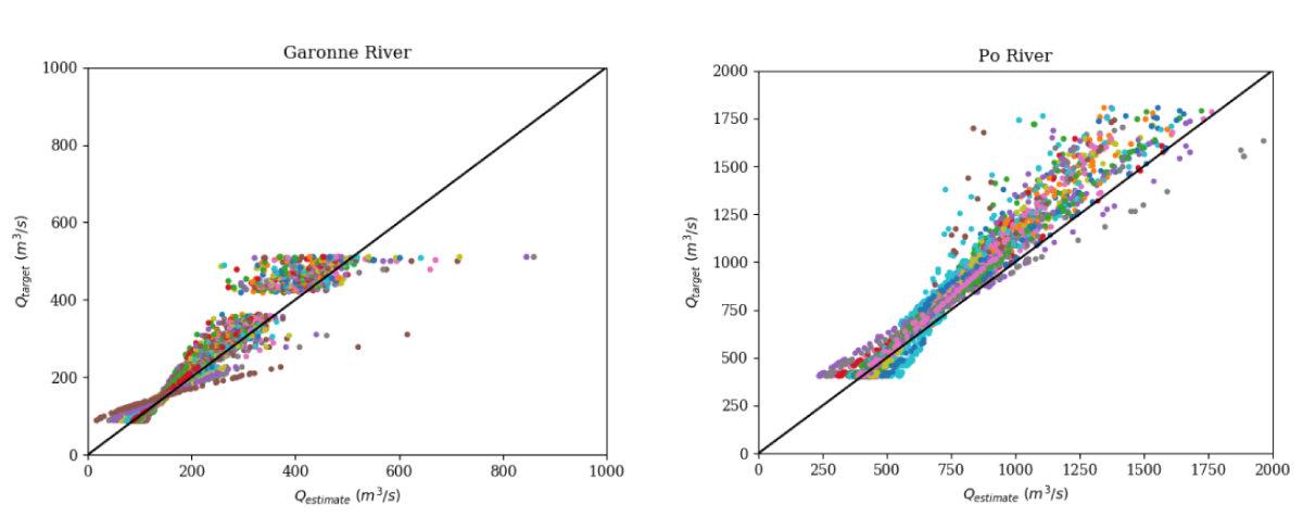
Below are presented the obtained results on ~100 km portions of the Garonne river (France), the Po river (Italy) and Sacramento river (USA). The rRMSE of the estimated discharge values (at the observation "hours scale") equals ~10% (see [1] for details).
Inference of the triplet (Q(x,t),A0 (x),K(h)) with the 1D model & VDA in Cal/Val configurations (1 day revisit)

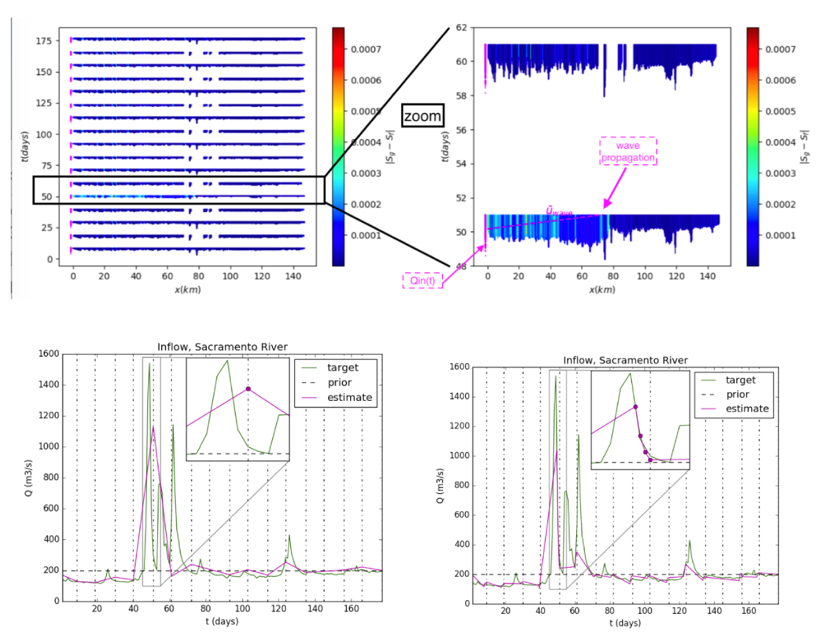
Inference of the triplet (Q(x,t),A0 (x),K(h)) from SWOT-HR data


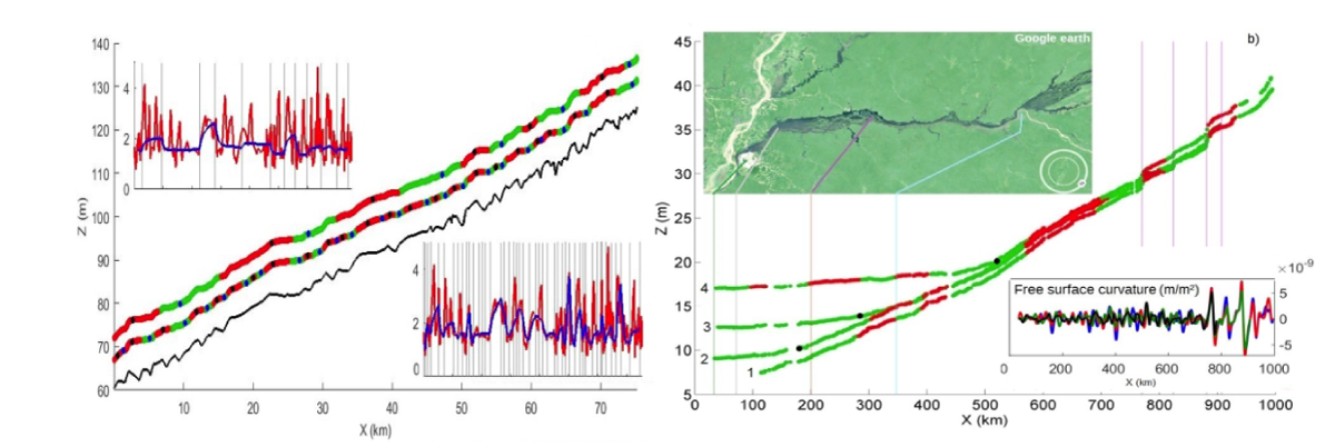
Discharge inversions from historical Nadir altimetry time-series
The HiVDI algorithm has been successfully applied to e.g. 8 years time-series of a historical Nadir altimetry dataset on a Xingu river portion (Amazonia), see Fig. 3.
River surface signal analysis and segmentation
Slopes and concavity of water surface elevation profiles are analysed, next it may be translated in terms of hydraulic controls. This enables a consistent river segmentation, see [2].
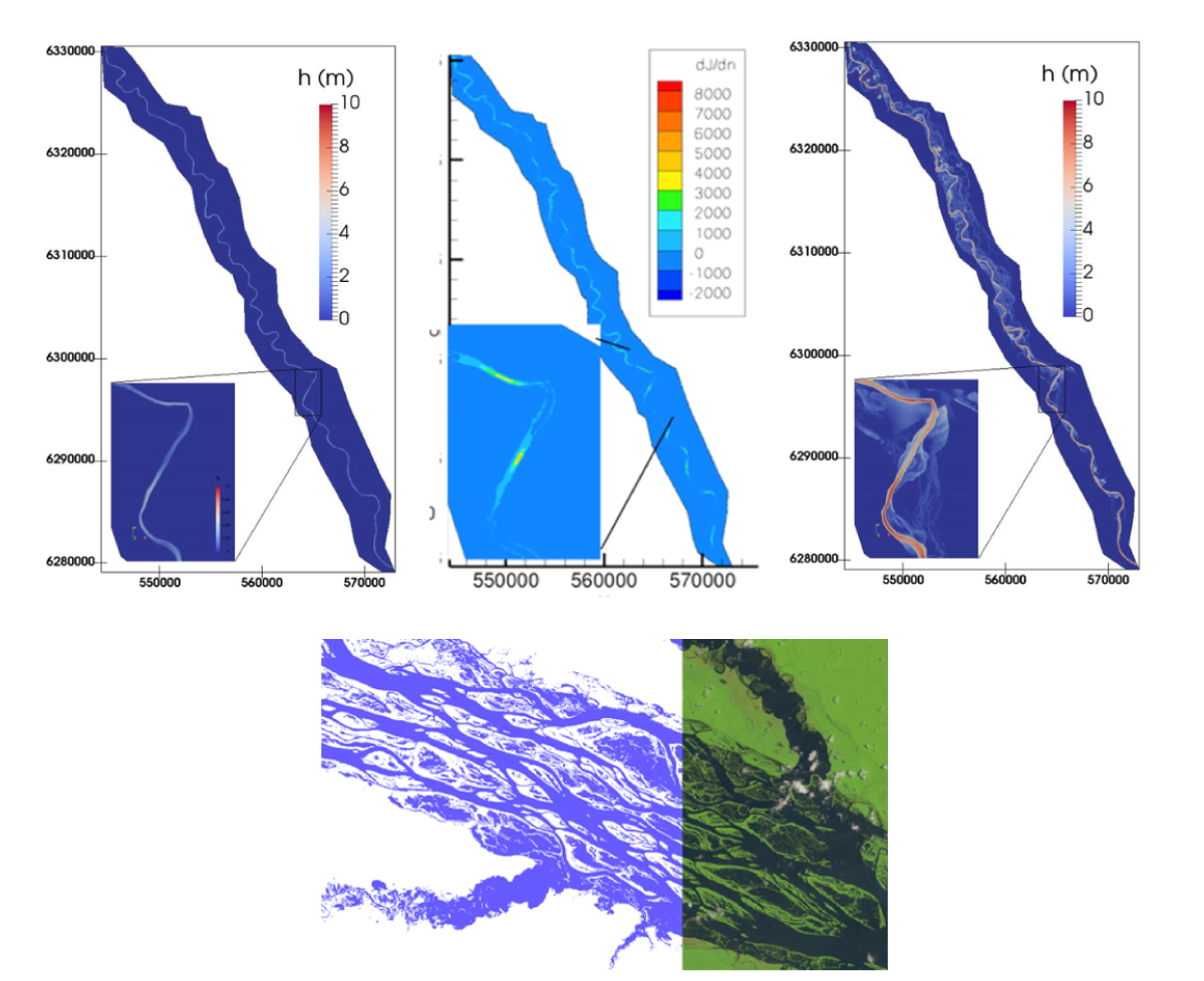
Inferences in braided flows and flood plains - 2D modeling
The same VDA processes as described before have been developed for 2D flows models [5]. This enables to model more finely braided rivers and flood plains, Fig. 5. In addition to infer the inflow discharge as in the previous 1D model cases, the VDA process is useful to finely analyze the flow sensitivity in flooded areas. The sensitivities may be with respect to the roughness coefficient and/or the DEM (bathymetry), Fig. 5.
Submitted References
[1] K. Larnier, J. Monnier, P.-A. Garambois, J. Verley. "On the estimation of river discharges from altimetry". Submitted.
[2] A.S., Montazem, P.-A., Garambois, Calmant S., Finaud-Guyot P., Monnier J., Medeiros D., Minear J., Biancamaria S. "Physical basis for river segmentation from water surface observables". Submitted.
Published References
[3] P. Brisset, J. Monnier, P.-A. Garambois, H. Roux. "On the assimilation of altimetry data in 1D Saint-Venant river models". Adv. Water Ress., vol. 119, pp 41-59, 2018.
[4] P.-A. Garambois, S. Calmant, H. Roux, A. Paris, J. Monnier, P. Finaud-Guyot, A. Montazem, J. Santos da Silva, "Hydraulic visibility: using satellite altimetry to parameterize a hydraulic model of an ungauged reach of a braided river". Hydrological Processes, Vol. 31, 4, 756-767, 2017.
[5] J. Monnier, F. Couderc, D. Dartus, K. Larnier, R. Madec, J.P. Vila. "Inverse algorithms for 2D shallow water equations in presence of wet dry fronts. Application to flood plain dynamics". Advances in Water Ressources (97), 11-24, 2016.
[6] M. Durand, C.J. Gleason, P.A. Garambois, D. Bjerklie, L.C. Smith, H. Roux, E. Rodriguez, P.D. Bates, T.M. Pavelsky, J. Monnier et al. "An intercomparison of remote sensing river discharge 1 estimation algorithms from measurements of river height, width, and slope". Water Resources Research, 52 (6), 4527-4549, 2016.
[7] J. Marin, J. Monnier. "Superposition of local zoom model and simultaneous calibration for 1D-2D shallow-water flows". Math. Comput. Simul. 80 (2009), pp. 547-560.
[8] I. Gejadze, J. Monnier. "On a 2D zoom for 1D shallow-water model: coupling and data assimilation". Comp. Meth. Appl. Mech. Eng. Vol. 196, issues 45-48, pp. 4628-4643, 2007.
[Dass] DassFlow computational software (Data Assimilation for Free Surface flows). Open sources available upon request.