Documents
Algorithm Development for SWOT River Discharge Retrievals
PI: Eric F. Wood (Dept. of Civil and Environmental Engineering, Princeton University)
Co-I: Ming Pan (Dept. of Civil and Environmental Engineering, Princeton University)
1. Introduction and Objectives
Water is central to human life on Earth. Besides the usefulness of near real time river discharge data for water management, there is a great need for observations of river discharge data to further our understanding of the global water cycle. Yet river flows are poorly monitored in many regions of the world, and the reporting on a global basis from in-situ sources has proved to be difficult. The SWOT mission is expected to dramatically enhance our ability to monitor terrestrial surface water bodies on Earth by measuring the elevation and slope of rivers and lakes. As the SWOT altimetry sensor can scan the surface repeatedly, the measurements of river discharge will be intermittent in both time and space. Thus, it remains a challenge to derive spatially complete and temporally continuous river discharge estimates from SWOT.
The over-arching goal of the project is to develop a set of algorithms and modeling systems to be used by the SWOT mission for the retrieval of river discharge estimates globally. Specifically:
- To develop a forecast/assimilation system that predicts river discharge, river inundation/water elevation by the assimilation of SWOT altimeter measurements, and can be implemented operationally for the retrieval of river discharge estimates globally.
- To derive spatially and temporally continuous estimates of discharge and water elevation throughout the river reaches within a basin from the intermittent SWOT measurements, through an advanced data assimilation algorithm based on [Pan and Wood, 2013].
- To validate the proposed algorithm for a diverse set of river types through OSSE-type studies and against observational datasets developed by collaborators Aires and Prigent.
- To perform sensitivity analysis on SWOT satellite/sensor configurations through OSSE experiments to test their impact on capacity, accuracy, and effectiveness of the mission.
2. Approach
2.1 Global River Routing Model and Hydrologic Model
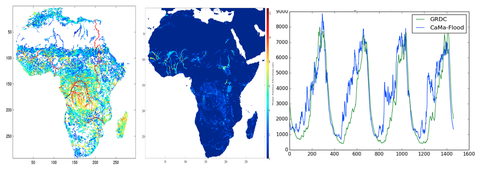
We propose to estimate river discharge and flood inundation areas through a forecast/assimilation system that utilizes the Catchment-based Macro-scale Floodplain (CaMa-Flood) river routing model that is modified to assimilate SWOT water elevation and slope measurements. CaMa-Flood is a global distributed river routing model is developed by [Yamazaki et al., 2011], which is forced by gridded runoff output from a LSM and calculates river discharge along a defined river network. It takes the water storage and river discharge at each grid as the prognostic variables, while others like water surface level and slope, are calculated from the water storage (Figure 1). In order to force the routing model, runoff fields will be generated from the Variable Infiltration Capacity (VIC) LSM [Liang et al., 1994; Liang et al., 1996].
2.2 Discharge Assimilation Algorithm
Because the river discharge at a specific gauge (SWOT crossing) location is an integrated response to the runoff for the entire upstream contributing area and water travel time, discharge measurements at different locations on the river contain overlapping information, and thus, their errors are highly correlated. Given this particular nature of discharge measurements, a consistent, comprehensive SWOT data assimilation system requires an algorithm that is able to assimilate measurements at all locations simultaneously and to propagate information across the river network in space and in time.
Different from observations of other hydrologic variables like soil moisture, which carry information at the time and location of the measurements, river stage or discharge observations made at a river gauging point contain discharge/runoff information for the entire sub-catchment that contributes to the gauge and for the time period when the water travels from upstream down to the gauge (see a depiction in Figure 2).
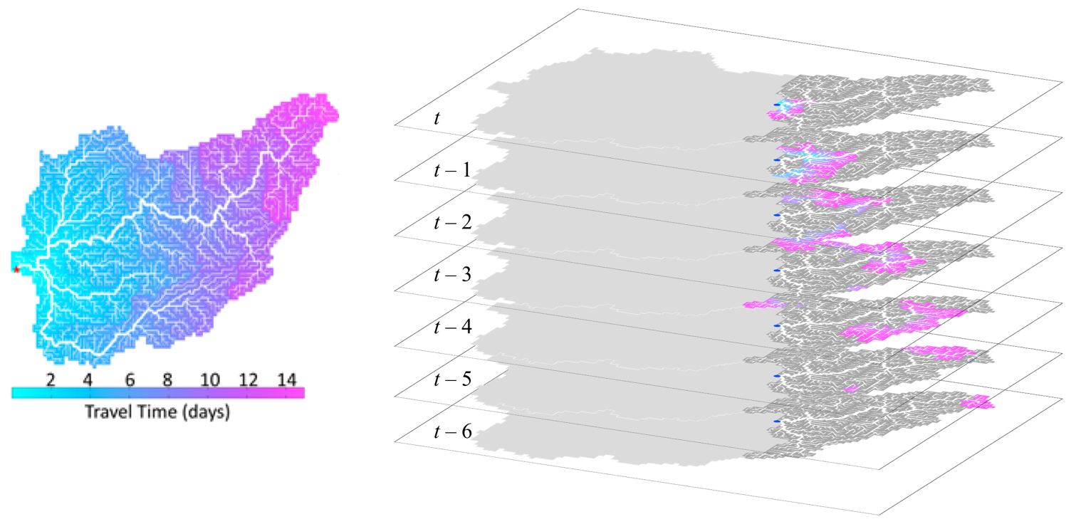
In short, river discharge is an integrated response to the runoff for the entire contributing area and water travel time. We can define a “range of influence” in the 3-D spatio-temporal domain for a discharge measurement as in Figure 2.
Because of this spanning range of influence, any attempt to assimilate or interpolate discharge information within a river basin must be able to propagate discharge information back in time and space across the entire range of influence in the 3-D spatio-temporal domain.
Another particular nature of river stage or discharge observations is that the range of influence for measurements at different times and locations overlap. For example, the contributing area of an upstream gauging point is fully included in that of its downstream gauging point. That means all stage or discharge observations within the same catchment are correlated, and all observations in the catchment need to be assimilated simultaneously into the river routing model.
A third particular nature of the problem is due to the spatially and temporally discrete nature of SWOT observations. As the river crossing locations of the SWOT ground tracks change from scan to scan, the simulation/assimilation algorithm must be able to simulate/assimilate SWOT estimates at any locations on the rivers at all time.
We argue that three capabilities of the assimilation algorithm are expected given that nature of the discharge assimilation problem:
- Propagate information across the entire range of influence in 3-D spatio-temporal domain.
- Assimilate all observations within the same river basin simultaneously.
- Simulate/assimilate at any locations on the rivers at all time.
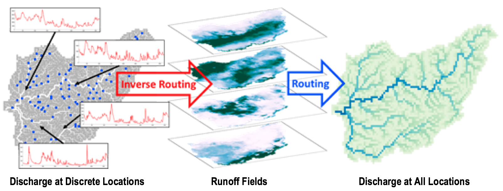
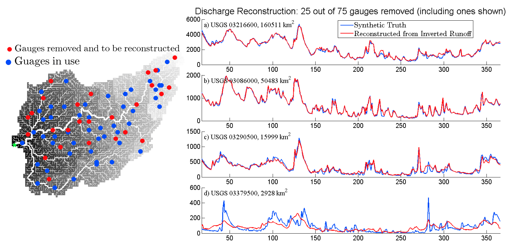
The closest algorithm meeting the above three requirements is the Fixed-Interval Smoother approach [Pan and Wood, 2013] developed for deriving the spatial fields of runoff from discharge time series observed at discrete gauging stations (the so-called “inverse routing”). See Figure 3. Through an “extravagant” state augmentation, the state vector used in this Fixed-Interval Smoother technique covers all pixels in an entire catchment and over a time interval that is much longer than the longest water travel time in the catchment. Such a configuration allows the discharge simulation and SWOT assimilation to be performed for any pixel at any time so that the observed information can propagate across its full range of influence in the 3-D spatio-temporal domain. It has been shown in [Pan and Wood, 2013] that this smoother technique is able to recover the spatial fields of runoff (lateral input flux to the river routing model) at all pixels and times from discharge measurements at gauging points thus able to reconstruct the discharge values at any pixel in the catchment (Figure 4). This powerful feature allows the spatially and temporally intermittent SWOT observations to be smoothly merged into a spatially complete and temporally continuous discharge dataset.
3. Analysis and Anticipated Results
Using our existing efforts in global scale modeling of river discharge (water elevation and inundation) as a foundation, and recent breakthroughs in discharge assimilation for river routing models, the project will:
- Develop a forecast/assimilation system that predicts river discharge, river inundation/water elevation by the assimilation of SWOT altimeter measurements, and can be implemented operationally for the retrieval of river discharge estimates globally. The algorithm is based on solving the Saint Venant equation for river discharge (and water elevation, inundate area etc.) that conserves momentum and continuity using the CaMa-Flood model [Yamazaki et al., 2011].
- Derive spatially and temporally continuous estimates of discharge and water elevation throughout the river reaches within a basin from the intermittent SWOT measurements. It is proposed to develop an advanced data assimilation smoothing algorithm based on [Pan and Wood, 2013], as well as a forecast system based on the SWOT elevation estimates as initial conditions. This algorithm will be compared with alternative algorithms developed within the SWOT science team, and modified if need be through collaborative science team feedback and validation studies so as to develop algorithms that best meet the needs of the mission.
- Validate the proposed algorithm for a diverse set of river types. Validation could include field campaigns based on the airborne SWOT simulator as well as model simulation studies (OSSE-type studies). In addition, collaborators Aires and Prigent have developed wetland data sets of water storage and change that can be used as validation.
- Perform sensitivity analysis on SWOT satellite/sensor configurations, for example, distance between tracks, time interval between tracks, pattern repeat time (revisit time), sensor characteristics like river detection width threshold and elevation errors. Different SWOT orbit and sensor configurations may affect the capacity, accuracy, and effectiveness of the SWOT mission in achieving its goals in monitoring the global surface water bodies. Through OSSE experiments with vary SWOT availability and error scenarios, we can investigate the tradeoff between various design parameters and performance expectations.
The proposed research activities are expected to significantly improve the SWOT-based monitoring and forecast of global river systems in terms of data continuity, completeness, quality, and physical consistency. The data records to be created for the SWOT mission will help achieve its mission goals, and will provide the critical river discharge data needed for water management and for hydrologists to better understand the global surface water dynamics, water use, and the global water cycle and its variability.