SWOT cryosphere animation: sea ice freeboard
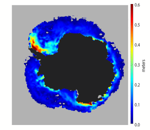
This animation shows estimates of average sea ice freeboard — or the amount of ice above the waterline — taken over a 21-day period from Aug. 8, 2023, to Jan. 14, 2024, by the Surface Water and Ocean Topography (SWOT) satellite. Sea ice freeboard is an indicator of the snow depth and thickness of the floating ice. Red and orange indicate thicker freeboards of roughly 1 to 2 feet (0.4 to 0.6 meters), while light and dark blues are associated with thinner freeboards less than 0.7 feet (0.2 meters).
SWOT, launched in 2022, is primarily designed to measure the height of water across nearly all of Earth’s surface including the ocean, lakes, reservoirs, and rivers. The satellite carries an instrument called a wide-swath altimeter which can provide the first 2D images of our planet surface topography. Even though the satellite wasn’t designed for sea ice monitoring, researchers have been able to retrieve sea ice freeboard for studying changes in the polar oceans.
Antarctic sea ice has undergone dramatic changes since 2016, with several sea ice minimum records set during the Southern Hemisphere summer (February). Estimates of sea ice thickness from altimeter missions like SWOT, offer crucial measurements of how sea ice is changing over time.
In comparison to prior estimates from other satellites, SWOT’s more frequent observations and greater spatial coverage over the polar oceans is helping researchers track features at finer scales, including how sea ice is changing in response to the changing climate. These observations will contribute to sea ice process studies, climate modeling, operational forecasts, and navigation.
